Ayrshire Alps Cycle Park
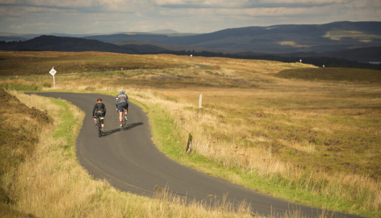
The hill roads of South Carrick make up the ultimate road cyclist’s playground. Popularly referred to as ‘The Ayrshire Alps’, the terrain offers fantastic scenery, cycle friendly roads, and a tough cycling challenge.
The ‘Ayrshire Alps’ are situated in South Ayrshire, nestled at the north end of the Galloway Forest Park. The area is popular with road cyclists for the abundance of hill climbs nestled among a fantastic network of quiet roads and trails.
The South Carrick area is known for its warm welcome, and has played host to several major cycling events each year including the Graeme Obree Sportive, the David Bell Memorial and the Tour Doonhame. Many of Britain’s top professional cyclists including Mark Cavendish and Chris Boardman cut their teeth here, competing in the former Girvan 3 Day Stage Race.
A grading system has been applied to the climbs similar to that used to grade ski resorts and mountain bike trail centres. This system is based on robust scientific testing: how the rider’s legs feel after each ascent !
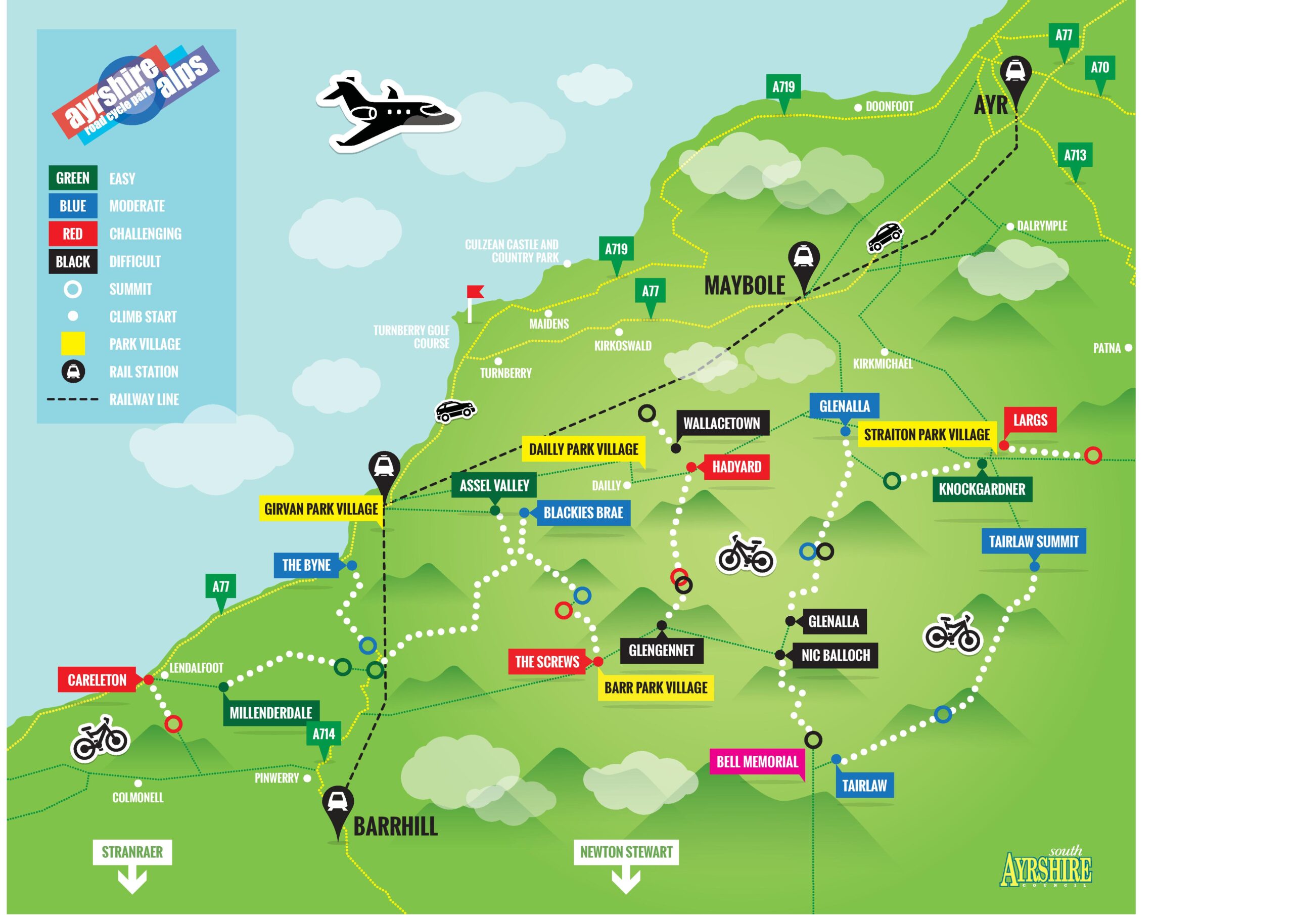
The climbs
| LOCATION | DISTANCE | AVERAGE | |
| Easy | Assel Valley | 10.3km | 0.80% |
| Easy | Knockgardner | 3.0km | 3.70% |
| Easy | Millenderdale | 4.7km | 2.50% |
| Moderate | The Byne | 4.5km | 3.70% |
| Moderate | Blackies Brae | 4.7km | 3.90% |
| Moderate | Glenalla (Cloyntie) | 7.0km | 3.40% |
| Moderate | Tairlaw Summit | 8.6km | 3.30% |
| Moderate | Tairlaw (Shalloch) | 4.0km | 4.30% |
| Challenging | Largs | 3km | 5.80% |
| Challenging | Carleton | 2.2km | 6.80% |
| Challenging | Hadyard | 5.4km | 4.60% |
| Challenging | The Screws | 2.9km | 4.80% |
| Difficult | Glenalla | 3.4km | 6.50% |
| Difficult | Glengennet | 2.8km | 6.90% |
| Difficult | Nic O Balloch | 3.5km | 7.60% |
| Difficult | Wallacetown | 2.3km | 7.80% |
Rides
THE SHARK
- 90mins riding (est)
- 2 climbs
- 20 miles
- 2000ft+ ascent
We call this the Shark because the route map very vaguely resembles a shark, see ? How clever ! We’re in Dailly for a short ride that will take no more than 2hrs. We head straight up Hadyard Hill, trek along the ‘secret valley’, and tackle the Black-rated Glenalla on our return.
This route also works great in reverse.
You can view the full route on our RideWithGPS profile page.
THE DAILLY 7UP
- 4-6hrs riding (est)
- 7 climbs
- 60 miles
- 6000ft+ ascent
Today we’re basing ourselves in Dailly for an assault of: Wallacetown, Blackie’s Brae, Glengennet, Glenalla (Cloyntie), Nic O Balloch, Tairlaw Shalloch and Knockgardner. Seven climbs in total, including three rated Black.
You can view the full route on our RideWithGPS profile page.
RATHER BE CLASSIC
- 5-7 hrs riding (est)
- 8 and 2 1/2 climbs
- 75 miles
- 6500ft+ ascent
The signature edition ride ! We asked round the world cyclist and Scottish Record Holder Gav McDonald of Rather Be Cycling to design us the ultimate 6hr ride through the Ayrshire Alps park. And oh boy, he did not disappoint !
Gav tells us “This is my all time favourite route in the Ayrshire Alps! It’s got everything – country, climbs, descents, minor roads, villages, a loop to the Coast at Lendalfoot (I’ve got that as a right handed loop as I like the climb over to Lendalfoot that way but it could be a left handed loop climbing Carleton). It’s also got the option of a detour into Girvan for a pub lunch or cafe stop.”
Start in the beautiful village of Barr and head straight for the Nick O’Balloch, pay homage to the Highwayman at Rowantree Toll before a sprint up Tairlaw Shalloch and into Straiton. Gav has us combining Knockgardner and Glenalla, before a return to the hidden valley. The climb over Glengennet deserves a refuel in Dailly before tackling the Byne and the gorgeous loop to Lendalfoot. A local boy, Gav sure knows how to plan a bike ride !
You can view the full route on our RideWithGPS profile page.
OMNIBUS 8
- 6-8 hrs riding (est)
- 9 climbs
- 88 miles
- 8000ft+ ascent
Eat a big breakfast ! Today we are going to attempt to ride over all the hill roads of the Ayrshire Alps, with nine climbs on the menu and the rest as descents. A leisurely start out of Girvan takes us up Blackie’s Brae for the amazing descent of the Screws. We’ve only just begun, but best be cautious and stock up in Barr before racking up the next summits of Glenginnet, Glenalla (Cloyntie), Nic O’Balloch and Tairlaw Shalloch. Phew, we’ve arrived in Straiton for some fruit loaf in the Buck before we head up Largs. A brief detour into East Ayrshire takes us out of the Park, but it’s all too brief a visit before we return to Straiton. Knockgardner is a Green ascent, but at this stage it might as well be a Red ! Still have energy in the tank? Head north to Wallacetown and try and hold your head up high on the descent to enjoy the view ! We finish with a rattle up the Assel Valley and a screaming descent back to Girvan via the Byne. You have earned those fish and chips !
You can view the full route on our RideWithGPS profile page.
Resort Villages
DAILLY
The most centrally located of our park resorts, Dailly is the ideal base to explore the Ayrshire Alps! Regular buses service the village, and the climbs of Wallacetown and Hadyard and both within a mile.
BARR
Hidden deep in the ‘Ayrshire Alps’ is the beautiful village of Barr. Stop in at the village post office to stock up on nibbles and enjoy the tranquil pace of life. But be warned: the only way out of Barr is back up a hill! Visit the Barr Village Website – www.barrvillage.co.uk
STRAITON
Many consider Straiton the heart of the area, having been welcoming cyclists for years ! Situated at the eastern end of the Park, Straiton is a great base to tackle Tairlaw, Largs and Glenalla. Conquered the Nic O’Balloch ? You’ll be ready for a well earned break in either the Buck tea room or Black Bull Inn !
GIRVAN
Girvan is the biggest town in the area, with a good rail link to Ayr and Glasgow. Having played host to the Girvan 3 Day for decades, local hoteliers and restaurateurs know exactly how to cater for a tired cyclist ! Situated on the beautiful Clyde coast, every visit to the Ayrshire Alps should include a visit to Girvan, not least for the fish and chips !
Wider cycling:
You can view other fantastic walking and cycling routes across South Ayrshire on this map maintained by the local authority.
About
The Ayrshire Alps is a concept with the aim of enriching the cycling experience in the South Carrick area through partnership working with community, tourism, local authority and enterprise. Our aim is to create Scotland’s first road cycling park, similar in ambition to the off-road trail centres found across Southern Scotland.
A network of signed hill climbs, stylishly mapped and promoted form the basis of the Park. This is supported by local community and business, providing all the appropriate resources and hospitality to welcome visitors.
The concept for the Ayrshire Alps Cycle Park was created by Christopher Johnson and the original site and brand was developed with the support of South Ayrshire Council.
Safety:
Ride the Ayrshire Alps is a fun challenge. 16 climbs, close together, in beautiful scenery. When you have finished your ride you are going to want to come back and complete the set. Therefore you are going to want to stay upright and safe.
Road Surface: We’re not going to lie, these are quiet moor roads that experience harsh conditions in winter. Therefore, we cannot guarantee a smooth pothole-free passage. The climbs of the Ayrshire Alps are on public roads which experience dynamic conditions, so cyclists beware ! You will also encounter the odd cattle grid (or three). More below.
Wild Animals: Many of the climbs in the area cross open moor land and it is not unusual to zip round a bend to find Daisy the cow munching on some tasty hay, oblivious to your climbing exploits. It is also common to have a nice clear descent of the Nic O’Balloch only to find Dolly the sheep teaching her kids the Green Cross Code. Just remember; she lives here, you are just visiting, so please show some respect and caution. And if you’ve ever hit a barnyard animal by bike you’ll know just how sore it is !
Other road users: Not including our animal friends, you’ll also encounter lots of other road users on your travels. Just last week we came across a dustbin lorry, a bus, a logging contractor’s van, and even a forestry commission minibus – all during one 3hr ride ! We refer you to the nice people at the Department for Transport and their handy little guidance document ‘The Highway Code’. We recommend that all visitors to the park follow it to avoid any unnecessary complications that might spoil your visit.
Phone reception (Lack of): In much of the park area the mobile signal is very poor. Those in the know will insist than you can get two bars when standing by the third pillar under the awning of the McCandlish Hall in Straiton (providing it is not raining) but otherwise it is a bit hit and miss. So long as we take sensible precautions this ‘mobile tranquility’ just adds to the joy of the park.
- Wear clothing appropriate for the weather (knowing it might change fast)
- Carry at least one spare tube and know how to carry out basic road side repair
- Just in case, always make sure you are carrying identification with an ICE (In Case of Emergency) number.